
Routes
A very frequent question when planning an E2E is the route in the far south-west. The main A30 through Cornwall & Devon (or Devon & Cornwall for JOGLE) is notorious - much of it is motorway in all but name yet cyclists may ride on it.
The content here has suggestions for a route from Land's End as far as Tiverton Parkway, with a supplementary route avoiding the A30.
MickF* from the CTC Forum has kindly created both .gpx and .pdf map files for viewing or download (the coloured routes on the map are the separate files)
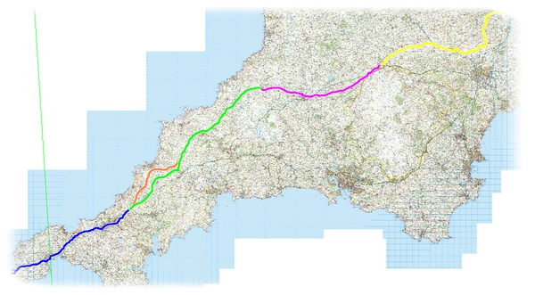
Click the link - the .gpx files will open a download window and the .pdf files will open the map in a new window (the file can then be saved)
The .gpx files can, of course, be reversed to load into GPS gadgets
.gpx files
Route 1 : Land's End - Three Burrows
Route 2 : Three Burrrows - Hallworthy
Route 3 : Hallworthy - Okehampton
Route 4 : Okehampton - Tiverton Parkway
Avoid A30 : Three Burrows - St Columb Major
.pdf maps
Route 1 : Land's End - Three Burrows
Route 2 : Three Burrrows - Hallworthy
Route 3 : Hallworthy - Okehampton
Route 4 : Okehampton - Tiverton Parkway
Avoid A30 : Three Burrows - St Columb Major
All the .gpx and/or .pdf files are provided free of charge in good faith, without warranty and are for personal use only.
* Mick, who lives in Cornwall, is a mutiple End-to-Ender, including a ride on a Raleigh Chopper towing a trailer.
A few notes to outline the "technical" requirements to ensure that the Route Index works effectively - covering file formats and the text used for searching.
GPX files
 The .gpx format has been adopted by most mapping systems to enable exchange of data between different, proprietary software and online services. In most cases the tool used to create your route will have an option to Save As or Export the route data as a .gpx file - follow the instructions and save the file on your computer ready to upload to the Route Index. That's it!
If your route has more than one .gpx file (perhaps a file per day) you will need to create a .zip file holding all the .gpx files. Most operating systems have this feature in-built, or there are a number of freeware options available.
Note : Garmin, perhaps the most popular GPS brand, has its own file format .tcx - if you have your route in that format you will need to convert it to .gpx (The free GPS-Babel software is one conversion tool). If you want to submit both a .gpx and the original .tcx file then you will need to create a .zip file to upload.
Routes as text listings/instructions
![]() If your route is written as a list of places or other instructions it can be added to the Route Index as a .pdf file for users to download and read/print. Most word processing software has the option to save documents in the .pdf format (If not PrimoPDF is a useful freeware tool). The ideal for .pdf uploads is a single file of the complete route, however if it's in more than one file you will need to create a .zip file.
If your route is written as a list of places or other instructions it can be added to the Route Index as a .pdf file for users to download and read/print. Most word processing software has the option to save documents in the .pdf format (If not PrimoPDF is a useful freeware tool). The ideal for .pdf uploads is a single file of the complete route, however if it's in more than one file you will need to create a .zip file.
Text for searching
 A brief description of the route using keywords that are likely to be searched on by the site visitors ... the text needs to have a title, the file type and be brief, perhaps including a list of overnight stops and possibly key places of interest (avoid the obvious "Land's End" or "John O'Groats" or other route start places)
AND do make sure that spelling is correct - the search facility will ONLY match precise words! It will also help the appearance of the Route Index if the text is typed conventionally using UPPER and lower-case (and no txt spk!)
It might be useful to draft the proposed text for your entry before you go to the file upload - you can then copy and paste the final text. Editing text after the entry has been made can only be done from the system end .... I don't want to have to do too much of that :-)
Maps and mapping
![]() The .gpx files that site visitors download should be possible to apply to most software mapping systems and online services - a small word of warning : in my experience, Google Maps is an excellent free tool used to drive almost all online services BUT there are many inaccuracies in the mapping data - roads that are shown that don't exist and roads that are on the ground but not on the Google maps.
The .gpx files that site visitors download should be possible to apply to most software mapping systems and online services - a small word of warning : in my experience, Google Maps is an excellent free tool used to drive almost all online services BUT there are many inaccuracies in the mapping data - roads that are shown that don't exist and roads that are on the ground but not on the Google maps.
Please READ THIS CAREFULLY - it's a complex topic!
The Route Index is a resource for prospective riders - routes submitted by past riders are listed for download.
There is no "official route" for the UK E2E and every rider has preferences and reasons for choosing a route . . that makes indexing and searching complex. Couple that with the various mapping and planning options and it gets really complicated!
To start the Route Index routes are listed as either .gpx or .pdf files.
.gpx which is (almost) universal across mapping software, online route planning services and, of course, GPS gadgets - should enable routes to be downloaded and applied to the method the user chooses.
![]() .pdf for written routes, as a simple document to print. (Most word-processing software has an option make .pdf fles)
.pdf for written routes, as a simple document to print. (Most word-processing software has an option make .pdf fles)
The Route Index within the Cycle : End-to-End website has been created to store the files in several categories - it's possible to scroll through the file descriptions, or search using keywords. The usefulness of the search is obviously driven by the descriptive text for the route.
 Each route listed will have only ONE file (for a route with multiple .gpx files they can be uploaded as a .zip file ... the download will be for the single .zip)
Thus it should be possible for someone to : find a suitable file in the Route Index; download a .gpx file; use that file in PC mapping software (e.g. Memory Map or Tracklogs) OR an online mapping service (www. bikemap. net, www. bikeroutetoaster. com etc ) OR load it to GPS mapping software (e.g. Garmin MapSource) OR direct to the GPS gadget.
Disclaimer: Cycle : End-to-End is listing the resources as a service without recommendation or endorsement. Use at your own risk! Submitters will be responsible for any copyright or usage licences etc.
Please read the Route Index main page first!
 Each route listed will have only ONE file (for a route with multiple .gpx files they can be uploaded as a .zip file ... the download will be for the single .zip)
To upload your file, simply complete the form below and attach the file (it MUST be .gpx or .pdf and be smaller than 2Mb) Give the file the descriptor title, the Route Index will add the category and sequential number.
AND most importantly make sure the text has useful keywords to help riders searching
Please use the SHIFT key for correct upper & lower-case text!!
{Form 12}
By submitting a route file you are agreeing that it may be made available without limitation through the Cycle : End-to-End website for download.
Routes submitted by riders for the free use of other riders.
IN DEVELOPMENT - Submissions will be invited (with a simple upload form) for riders to make available on a free basis routes, sections of routes etc in GPS file formats (normally .gpx), mapping software files or even documents. Submitters will be responsible for any copyright or usage licences etc.
The resource will be available in the same type of structure as the Journals - that is a library segmented by LEJOG, JOGLE, Other etc.
Note : Cycle End-to-End is merely listing the resources as a service with no recommendation or endorsement whatsover. Use at your own risk!
September 2010 : If you have a route to submit please e-mail This email address is being protected from spambots. You need JavaScript enabled to view it. until an online input form is available.